Mount Everest is a bit taller than we had known, says Nepal and Chinese Authorities
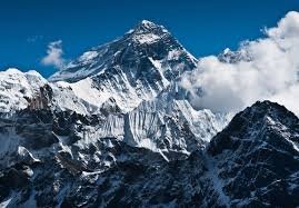

Mount Everest, the highest point on Earth has a newly announced elevation. It is 29,031.69 feet above sea level, according to survey results presented recently, which is more than two feet higher than the altitude previously recognized by the government of Nepal.
Kathmandu and Beijing had differed over its exact height but after each sent an expedition of surveyors to the summit, they have agreed that the official height is 8848.86 metres, a bit more than their previous calculation.
The joint statement by the Survey Department of Nepal and Chinese authorities about the announcement of the elevation was made on December 8. The authorities stated that it is the result of the culmination of a multiyear project to definitively measure the legendary mountain.
According to Himalayan Database, Everest has been climbed 10,184 times by 5,789 people from both sides since it was first scaled by New Zealander Sir Edmund Hillary and Sherpa Tenzing Norgay in 1953.
Why was the height of Everest questioned in the first place?
Many experts believed that a major earthquake in 2015, which was of 7.8 magnitudes and that killed nearly 9,000 people in Nepal may have had an impact on Mount Everest's height. The same earthquake had caused many avalanches, which buried parts of the base camp at the mountain killing at least 18 climbers.
Scientists had found that some other Himalayan peaks such as Langtang Himal, mostly to the north of Kathmandu and close to the epicentre, had reduced in height by approximately a metre after the said earthquake.
While others have argued that the Everest may have actually grown over the time because of the shifting tectonic plates it sits on. Experts say major earthquakes can result in that process being reversed.
And this was why the Everest was re-measured – 2015 Earthquake.
How was Mount Everest re-measured?
As per practice, the height of mountains is measured with the mean sea level as the base. Nepal used the Bay of Bengal as its sea level. India had already surveyed a point closer to Everest, near the India-Nepal border, from the bay. This served as a readymade option which provided the Nepalese surveyors with the height at that point. From there, the Nepalese team built a network of line-of-sight stations stretching nearly 250 kms creating a chain of points it could measure and add together.
The Chinese surveyors used the Yellow Sea in the eastern province of Shandong as their sea-level base. Surveyors from both sides also used trigonometry formulas to calculate the height of the summit. The formulas they used calculate the height of a triangle by multiplying its base with its angles.
The Nepalese surveyors went up to the summit last year, while the Chinese surveyors went up in May, becoming the only team to reach the top in 2020. This happened after Nepal suspended all expeditions during the coronavirus pandemic and China banned foreign travellers.
Jiang Tao, the associate researcher at the Chinese Academy of surveying and mapping, informed the state-run China Daily, "Once the surveyor's beacon had been placed on the summit, surveyors at stations around the summit measured the distance from the six points to the beacon, which meant at least six triangles could be calculated to determine the mountain's height."
And that is how it was done!