Delhi's air quality very poor, likely to improve
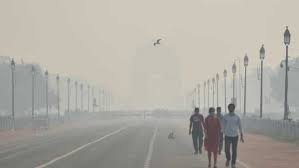

New Delhi: Delhi's air quality was recorded in the upper end of the very poor category on Sunday, and is likely to improve over the next two days due to a predicted increase in the wind speed.
The air quality had turned severe on Saturday with slow wind speed allowing accumulation of "locally-generated" pollutants, according to officials of the India Meteorological Department (IMD).
The city's air quality index (AQI) was 394 at 9 am. The 24-hour average was 404 on Saturday, which falls in the severe category.
It was 382 on Friday, 341 on Thursday, 373 on Wednesday, 367 on Tuesday, 318 on Monday and 268 on Sunday.
Air pollution in the neighbouring cities of Ghaziabad (AQI 430), Greater Noida (404) and Noida (404) remained in the severe zone.
An AQI between zero and 50 is considered "good", 51 and 100 "satisfactory", 101 and 200 "moderate", 201 and 300 "poor", 301 and 400 "very poor", and 401 and 500 "severe".
The wind speed remained slow allowing accumulation of pollutants generated locally, V K Soni, the head of IMD's environment research centre, said.
Easterly winds carrying moisture also led to formation of secondary particulate matter. All these factors together pushed the air quality in the 'severe' zone, he said.
However, Soni said, the air quality is likely to be in the poor category by Monday due to an expected increase in the wind speed.
According to the IMD, the maximum wind speed is likely to be 8 kmph on Sunday and 15 kmph on Monday.
The minimum temperature was 11.4 degrees Celsius on Sunday and the maximum is likely to settle around 28 degrees Celsius, the weather department said.
Calm winds and low temperatures trap pollutants close to the ground, while favourable wind speed helps in their dispersion.
Mahesh Palawat, an expert at Skymet Weather, a private forecasting agency, said Delhi recorded a rise in the maximum and minimum temperature in the last few days which can be attributed to light, warm easterly winds and plenty of sunshine during daytime due to clear skies.
The city is likely to record above normal temperatures till November 10, he said.
However, Palawat said a fresh Western Disturbance will trigger moderate to heavy snowfall in Jammu and Kashmir, Himachal Pradesh and upper reaches of Uttarakhand.
After the WD withdraws, icy winds from snow-clad western Himalayas will blow towards the plains, leading to a drop in the mercury, he said.
Shallow to moderate fog is also predicted over the next two days, the IMD said.
The central government's Air Quality Early Warning System for Delhi said the city's ventilation index -- a product of mixing depth and average wind speed is likely to be 1,000 m2/s on Sunday.
Mixing depth is the vertical height in which pollutants are suspended in the air. It reduces on cold days with calm wind speed.
A ventilation index lower than 6,000 sqm/second, with the average wind speed less than 10 kmph, is unfavourable for dispersal of pollutants.