Aerial view from NASA satellites helping Turkey, Syria earthquake response

Washington: After the massive earthquakes that struck southern Turkey and western Syria on February 6 and killed thousands, NASA on Saturday said it is working to share its aerial views and data from space to aid relief and recovery workers, as well as improve its ability to model and predict such events.
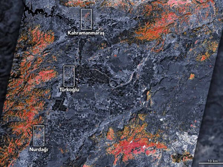
Scenes collected before and after the earthquake were used by a team of scientists from the Earth Observatory of Singapore and NASA's Jet Propulsion Laboratory in Southern California to create something called a damage proxy map for Turkey.
These maps compare before and after radar images of a given event to see how the landscape has changed.
"NASA's hearts and minds are with those impacted by the earthquakes in Turkey and Syria," said NASA Administrator Bill Nelson.
"NASA is our eyes in the sky, and our teams of experts are working hard to provide valuable information from our Earth-observing fleet to first responders on the ground," he added.
One of NASA's key capabilities is an expertise with synthetic aperture radar, or SAR.
Viewing Earth in all weather conditions, day or night, SAR is used to measure how the ground moves and built landscape changes after this type of event.
"We don't know everyone who is using this information or how, but we are fortunate to have heard back from a few groups. For instance, the World Central Kitchen - which is providing food to those who've been displaced - have let us know they make use of it," said Lori Schultz, NASA's disaster coordinator for this earthquake.
In addition to assessing damage, NASA scientists use space- and ground-based observations to improve the agency's ability to understand related events that cascade from the original natural disaster.
While not in use yet, NASA scientists are hoping to add a new tool to assess the aftermath of the quake.
The Earth Surface Mineral Dust Source Investigation, or EMIT, instrument was launched to the International Space Station in July 2022.
As part of its observations of the composition of material in Earth's atmosphere, it can assess methane emissions.
When passing over the earthquake site, measurements of increased or new emissions could point to events not otherwise easily spotted from space.
As search and rescue efforts continued for a sixth straight day on Saturday to find more survivors, the number of people killed following the devastating earthquakes that struck Turkey and Syria on February 6 has reached at least 23,831.